
WEATHER FORECAST
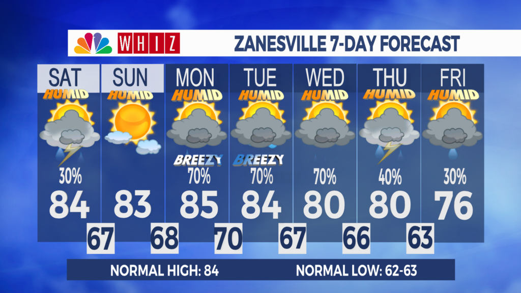
Latest Forecast (Zanesville, OH):
Friday Night: Mostly cloudy, with patchy fog and a 70% chance of rain and storms. Light and variable wind. Low 68
Saturday: Mostly cloudy, with a 30% chance of rain and storms. SW 5-10. High 84
Saturday Night: Partly cloudy, with patchy fog and a 20% chance of rain and storms. SW 5, then calm. Low 67
Shower and storm chances continue into Saturday:
An unstable atmosphere and abundant moisture will support a low chance of showers and storms in the region this evening. A storm could become strong enough to produce damaging wind gusts and heavy downpours that could result in isolated flash flooding. Additional showers and storms are likely tonight and early Saturday morning as an upper-air disturbance slides through.
Much of Saturday is dry, with a little sunshine and highs in the mid-80s. A few more showers and thunderstorms are forecast to cross the region late Saturday into Saturday night with another upper-air disturbance. The risk of severe storms and flash flooding is low.
The latest weather models are trending towards a dry Sunday, with highs in the 80s.
Daily chances of precipitation are expected throughout next week as multiple upper-air disturbances pass through from the northwest. Early next week is hinting at both the risk of flash flooding and severe weather. Stay tuned to the forecast for updates.
Have a great day!
-Chief Meteorologist Keaton Lewis
Contact Me!
Facebook: Meteorologist Keaton Lewis
Instagram: keatonlewiswx
Email: klewis@whiznews.com
Forecast
The WHIZ Weather Team
