
WEATHER FORECAST
Latest Forecast:
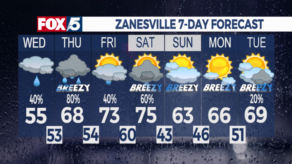
Wednesday: Isolated showers. High 55
Wednesday night: Scattered showers. Isolated storm. Low 53
Spring-like pattern continues:
Expect scattered to widespread rainfall Wednesday night, with an isolated storm chance. Temperatures on Wednesday will warm to the mid-50s, and several locations will see highs in the upper 50s. The spring-like pattern will continue for the remainder of the workweek, as rain and storm chances persist, with increasing highs. Temperatures will be close to 70 on Thursday, but scattered showers and storms are likely. Especially during the afternoon and evening. There is still a small severe weather threat for southwestern Ohio on Thursday, but the viewing area is still out of that threat.
Any showers leftover will taper off by Friday morning, and sunshine will return by Friday afternoon! Expect plenty of sunshine for the rest of Friday, with highs warming to the low to mid 70s!! Sunshine will continue for much of Saturday, but a cold front will bring scattered showers and storms during the later parts of the day. We will need to watch the cold front closely, as a storm could turn strong or severe. The warming trend will continue on Saturday, with highs in the mid-70s. The cold front will bring slightly cooler air on Sunday, as highs will only warm to the low 60s. The skies will remain mostly cloudy Sunday morning, but those clouds will clear out by the afternoon.
Expect mostly clear skies for the rest of the weekend. High pressure will take over the forecast by Monday! The high pressure will bring partly cloudy skies throughout the day, and conditions will be dry. Clouds will increase throughout next Tuesday, as a low will track through the Northern Plains and Great Lakes. The low will stretch a cold front across the Midwest, which will bring rain and storm chances late Tuesday and next Wednesday. Temperatures are also looking to stay above normal through the extended forecast, with highs in the 60s and 70s once again.
Contact me!
Instagram & X: Johnny_GormlyWx
Facebook: Meteorologist Johnny Gormly
Email: Jgormly@whiznews.com
Forecast
The WHIZ Weather Team

Because Local Matters 