
WEATHER FORECAST
Latest Forecast (Zanesville):
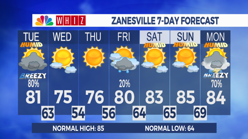
Monday Night: Partly cloudy. Light SE wind becoming SW. Low 68
Tuesday: Mostly cloudy. 80% chance of rain and storms. SW 5-10, G 25. High 81
Tuesday Night: Partly cloudy. 30% chance of rain and storms. W 5, becoming NW. Low 63
Severe weather and flooding threats on Tuesday:
The workweek is off to a pleasant start. High pressure has kept skies fair, temperatures climbed above 80, and humidity levels have been generally comfortable today. Clouds will return to the area this evening and tonight with our next weather maker.
A strong low-pressure system will track across southern Ontario on Tuesday, bringing rounds of showers and thunderstorms to our area, starting in the morning. Many storms in the afternoon and evening could be severe, with damaging wind gusts as the primary concern, though large hail and tornadoes are also possible. Additionally, storms could produce heavy rainfall, resulting in flash flooding. Monitor the latest forecasts and make sure you can receive watches and warnings. Activity should wrap up Tuesday night as a cold front slides through.
A departing cold front and a building high-pressure system will bring mostly clear skies and cooler-than-normal temperatures on Wednesday, with highs in the mid-70s. Overnight lows will likely be in the 50s for the first time this month.
Looking at the rest of the extended forecast, temperatures stay below average, and conditions are pretty much dry the rest of the workweek as high pressure remains in control. This weekend looks great for outdoor activities, as skies will be mostly clear, and temperatures will be around average.
Have a great day!
-Chief Meteorologist Keaton Lewis
Contact Me!
Facebook: Meteorologist Keaton Lewis
Instagram: keatonlewiswx
Email: klewis@whiznews.com
Forecast
The WHIZ Weather Team
