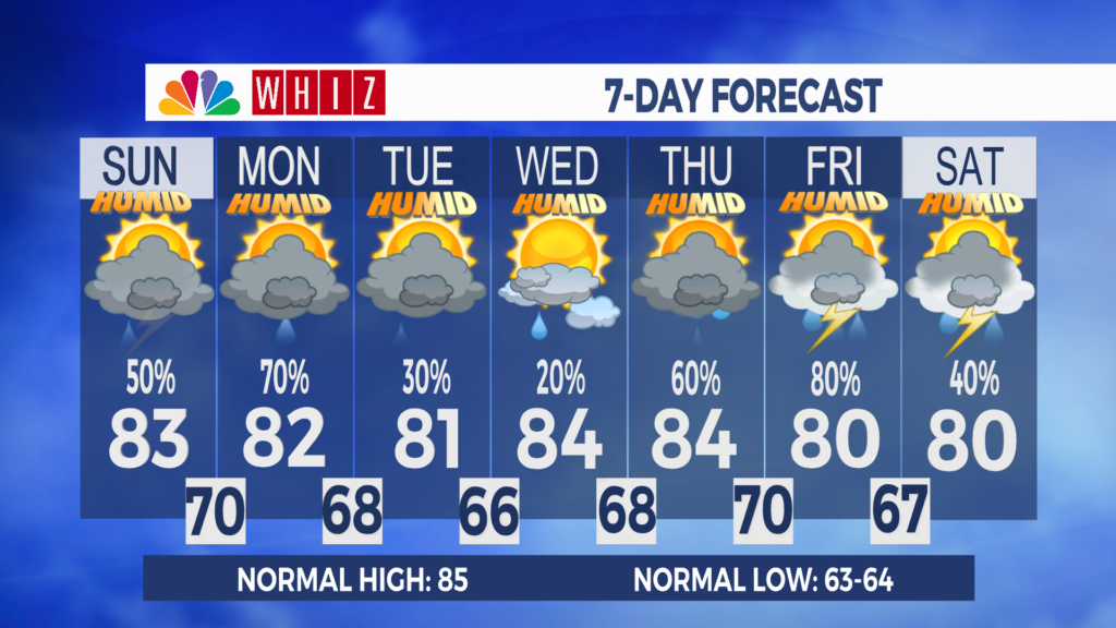
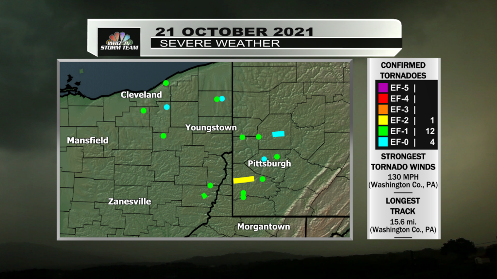
FINAL: 17 Tornadoes Confirmed from Thursday’s Thunderstorms
UPDATED: 10:00 PM EDT Monday, 25 October 2021
The National Weather Service Forecast Office in Cleveland, OH (NWS Cleveland) and the National Weather Service Forecast Office in Pittsburgh, PA (NWS Pittsburgh) have both concluded their surveying of the damage left behind from Thursday’s storms.
In total, 17 tornadoes were confirmed; 6 occurred around Northeast Ohio, 2 around the Wheeling, WV area, and 9 around the Pittsburgh, PA area.
6 individual supercell thunderstorms which developed ahead of an advancing cold front were responsible for producing all 16 tornadoes. A seventh supercell thunderstorm was present, but this one did not produce any known tornadoes.
Two of these supercell thunderstorms tracked over our region; the first one traveled from Gratiot, OH through northern Guernsey County, and into Washington County, Pennsylvania. This thunderstorm produced it’s first tornado in Mount Pleasant, OH. This EF-1 Tornado tracked roughly a half mile and reached estimated sustained winds of 100 mph. This tornado occurred at around 7:03 PM and dissipated at around 7:05 PM.
This thunderstorm would then go on to produce the strongest tornado of the event; a high-end EF-2 Tornado in Washington County, PA. This tornado tracked for 15.6 miles and is estimated to have had peak winds of 130 mph (just shy of the threshold for an EF-3 rating). This tornado developed at around 7:30 PM and dissipated at around 7:57 PM. This tornado caused damage to several residential structures, including a house which had it’s roof torn off as well as some of the walls collapsing. This tornado also destroyed a barn nearby.
A few moments later, at around 8:07 PM, this thunderstorm produced an EF-1 Tornado in northeastern Washington County, PA. This tornado tracked for roughly 1.5 miles and is estimated to have had peak winds of 95 mph. Damage was observed in some residential areas, where many homes sustained window damage, and some roof damage.
The second supercell thunderstorm began to attain noticeable rotation in southern Guernsey County near Byesville. This thunderstorm would go on to produce an EF-1 Tornado at around 7:06 PM just east of Warnock, OH in Belmont County. This tornado tracked for 6 miles, with intermittent touchdowns. A local business had lost it’s roof, and a motor home was also blown over. Additional tree damage around these areas was observed.
At around 7:58 PM, this thunderstorm would produce another tornado, an EF-1 Tornado near West Finley, PA. This short lived tornado tracked for a half mile and is estimated to have had peak winds upwards of 100 mph. A barn was completely destroyed and several trees were snapped and uprooted.
There were no reports or any confirmed tornadoes in our region, though a Tornado Warning had been issued for Guernsey County at one point during the event. This warning was attached to the first supercell thunderstorm mentioned in this article.
The Enhanced Fujita (EF) Scale uses damage to estimate the winds of a tornado, and these winds are classified into 6 categories from EF-0 to EF-5…
EF0: 65 – 85 mph
EF1: 86 – 110 mph
EF2: 111 – 135 mph
EF3: 136 – 165 mph
EF4: 166 – 200 mph
EF5: >200 mph
It should be noted that while not as frequent, tornado outbreaks are known to occur in Ohio during the autumn months.
That’s your weather!
-Timmy
UPDATED: 10:46 PM EDT Friday, 22 October 2021
(WHIZ-TV) – At least thirteen tornadoes are confirmed to have occurred across eastern Ohio and western Pennsylvania on Thursday, 21 October.
The National Weather Service Forecast Office in Cleveland, OH (NWS Cleveland) has confirmed that six tornadoes occurred across Northeast Ohio.
An EF-1 Tornado was produced a few miles east of Brunswick, OH in Medina County. This tornado was on the ground for roughly 2.5 miles.
An EF-1 Tornado occurred near Wickliffe, OH in Lake County. This tornado was short-lived.
A high end EF-1 Tornado with winds estimated to be upwards of 110 mph occurred in Stark County, just west of North Canton. This tornado was captured on video.
A fourth tornado, an EF-0, occurred north of Hudson, OH in Summit County.
The fifth tornado, an EF-1, was roughly 3 miles north of Cortland, OH in Trumbull County. This tornado was on the ground for roughly 0.6 miles.
The sixth tornado, an EF-0, occurred just northeast of Cortland from the same storm. This tornado was very short lived.
The National Weather Service Forecast Office in Pittsburgh, PA (NWS Pittsburgh) confirms that at least 7 tornadoes occurred. Surveys are still on-going, and the NWS Pittsburgh expects that the surveys may take a few more days.
However, three of the tornadoes have been completed, amoung them was an EF-1 tornado which occurred near Mount Pleasant, OH in Jefferson County. Another EF-1 Tornado was confirmed to have occurred just east of Warnock, OH in Belmont County.
NWS Pittsburgh will also survey damage around Butler and Beaver County in western Pennsylvania to determine if the damage was that of a tornado. These surveys are expected to take place on Saturday.
The Enhanced Fujita (EF) Scale uses damage to estimate the winds of a tornado, and these winds are classified into 6 categories from EF-0 to EF-5…
EF0: 65 – 85 mph
EF1: 86 – 110 mph
EF2: 111 – 135 mph
EF3: 136 – 165 mph
EF4: 166 – 200 mph
EF5: >200 mph
It should be noted that while not as frequent, tornado outbreaks are known to occur in Ohio during the autumn months.
This article will be updated as more information becomes available.
That’s your weather!
-Timmy
PREVIOUS UPDATE: 10:46 PM EDT Thursday, 21 October 2021
(WHIZ-TV) – A strong cold front pushed through eastern Ohio and into western Pennsylvania on Thursday Afternoon. In doing so, rain showers and thunderstorms developed, some of which went on to produce tornadoes.
At least three tornadoes are believed to have occurred around Northeast Ohio, including two which possibly tracked through some of Cleveland’s south suburbs. Another of tornado was captured on video as it passed nearby North Canton, OH.
While not officially yet surveyed, the National Weather Service Forecast Office in Cleveland, OH (NWS Cleveland) believes that more tornadoes may have occurred, as several “tornado debris signatures” (TDS) were detected on radar. NWS Cleveland will be sending out survey teams beginning Friday Morning. Depending on the amount of damage, the survey may continue into the weekend.
Several TDSs were also seen on radar imagery around the Wheeling, WV and Washington County, PA area and into the Pittsburgh, PA metropolitan as well. One tornado was reported to have occurred around Mount Pleasant, OH.
The National Weather Service Forecast Office in Pittsburgh, PA (NWS Pittsburgh) which covers east central Ohio, has not yet announced where and when they will conduct surveys.
At this time, no tornadoes are believed to have occurred in our immediate area, though the storm that produced the tornado report near Mount Pleasant did at one point traverse through Guernsey County, prompting a tornado warning at around 6:30 p.m. which was in effect for northeastern Guernsey County.
While not frequent, tornado events during the autumn months in Ohio is not uncommon.
Additional details on the storm survey results will be updated on this article.
On a side note: the NWS Cleveland issued 11 Tornado Warnings on Thursday Afternoon. The last time that NWS Cleveland issued 10 or more Tornado Warnings for one event was the night of 12-13 June 2013.
That’s your weather!
-Timmy
ORIGINAL ARTICLE BELOW…
(WHIZ-TV) – Strong thunderstorms moved through eastern Ohio on Thursday (21 October), producing gusty winds and even a few tornadoes.
The thunderstorms developed along a cold front which was moving through Ohio during the day on Thursday.
At least two tornadoes are reported to have occurred, however, damage reports are still coming through, and there were likely additional tornadoes.
The majority of the tornadic activity was focused around the southern Cleveland, OH metropolitan, including a photographed tornado near Canton, OH. Additional tornado activity occurred around the Wheeling, WV area, and the Pittsburgh, PA metro.
The National Weather Service will be conducting surveys across the effected areas on Friday.
That’s your weather!
-Timmy