WEATHER FORECAST
Latest Forecast (Zanesville):
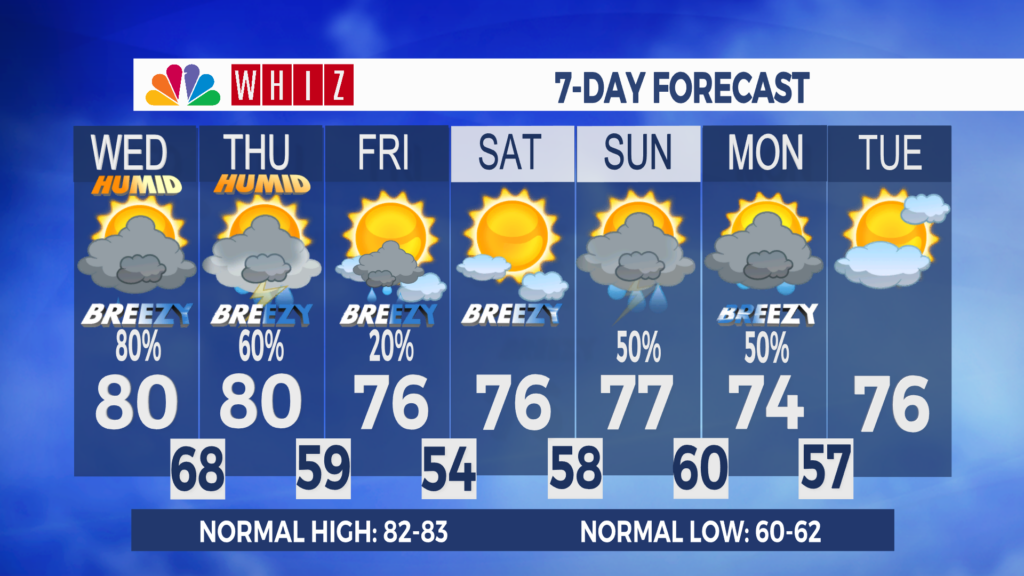
Wednesday: Increasing clouds. Evening shower/storm. SW 5-10. High 80
Wednesday Night: Mostly cloudy. Showers and thunderstorms. SE 10-15, G 35 mph. Low 68
Severe storms possible late Wednesday into Thursday:
We’ll stay dry for most of Wednesday, with highs around 80. Shower and thunderstorm chances, as well as winds, will pick up Wednesday evening into Wednesday night as a powerful weather system moves through the Great Lakes. There is a potential for severe storms and flash flooding late Wednesday through Wednesday night, with all modes of severe weather possible. The intensity of this system will likely generate wind gusts over 30 mph outside of thunderstorms. Monitor the latest forecasts and make sure you can receive watches and warnings.
Shower and thunderstorms will be ongoing early Thursday morning, with an additional severe storm possible. The rain looks to move out by late morning or early afternoon, with widespread totals of a half inch and locally higher totals possible. The rest of the day will be partly sunny, breezy, and warm, with highs around 80.
Have a great day!
-Chief Meteorologist Keaton Lewis
Contact Me!
Facebook: Meteorologist Keaton Lewis
Instagram: keatonlewiswx
Email: klewis@whiznews.com